September 28, 2007

GNP: Pacific Side

We wandered into our Avalanche Creek campsite at night and woke up to this. There is a nice easy trail at the campground (the Trail of Cedars), which meanders through a section of forest that, amazingly, hasn't burned since the 1600s. We strolled along it after breakfast and admired the sylvanity of it all.


This water (Avalanche Creek) was snow the day before.
Melissa and Esther played Keebler elves in a hollow cottonwood tree. The cottonwoods around here were super tall and straight, unlike the Nebraskan ones we're used to (think wider and branchier). This one was still very much alive, despite its hollowness.

For eons, Avalanche Creek has flowed through a narrow gorge and carved bowls and weird Gaudi-esque Art Nouveau shapes into solid bedrock (pink=granite, right Dad?).

The cedars have pretty shallow roots for being as tall as they are. I wonder how long ago this monster tipped over.
After the hike we took to the road. There are an abundance of silvery threadlike waterfalls all over the place. Once you get to the mountain part of the road, the bridges don't cross streams--they span waterfalls.

We like the colors in this picture. This chunk of mountain is the beginning of what's called the Garden Wall.

We're almost to the top now, looking down at a spectacular glacial valley. Which reminds me: not to be too political or anything, but Mr. Gore is doing the science a disservice when he laments the fact that Glacier National Park won't have any glaciers in it by 2050 or so. Well, Al, it wasn't named "Glacier National Park" because of the glaciers in it now, which are puny little modern glaciers, and did nothing to create the present scenery. It was so-named because of the humongous glaciers that carved out the landscape like giant spoons long, long, loooooooong ago, and disappeared tens of thousands of years before the first Ford Excursion blighted this fair planet. We aren't helped by sentimentality for that which never was.

next: the Hudson Bay and Atlantic sides

September 20, 2007

Ludwig Crests the Crown of the Continent

Going-to-the-Sun Road is the road through the park and is probably the only way most visitors experience it (the park). The two things that struck me, first when I saw pictures of it (the road), and then even moreso when I drove it, were: (1) someone thought, "we should build a road here", and (2) they built a road there. The road itself is a work of art in a way, a work in progress, as the environment does its damnedest every year to reclaim big parts of it.

On our previous visit we took the road East-to-West and hugged the mountains, but this time we went the other, more vertigo-inducing way, West-to-East. That's Esther, Melissa, and Ludwig (l to r). Turnouts along the way give you a chance to take pictures.

This isn't the best picture, but the Triple Arches here help to show why the existence of the road is remarkable. It was built by hand, incidentally, and that cliff keeps going down.


That stripe is the road.


Proof that Ludwig made it to the top: Logan Pass, elevation 6646'. I listened to a ranger tell a group that last Winter, the weather station on top of the visitors center atop the pass recorded two weeks of 155 mph winds. It's closed during Winter because it's under several feet of snow from early-October until mid-June. (Parts of the pass get 70+ feet of snow.) I thought Ludwig was going to be the oldest vehicle up there until a 1955 Dodge pulled in next to us.


Esther and I got a closer look at this waterfall next to the road on the Hudson Bay side of the pass.

The next day we headed out around the Eastern and Southern edges of the park. Along the way we crossed another of North America's important divides, the Hudson Bay Divide (6015'). The lack of a sign bespeaks of geographic illiteracy and of a general Atlantic/Pacific bigotry, I think.


Driver Found.


About one of every seven photos like this turned out, taken while sticking my arm out the rear side window.

I'll admit that I'm confused. This sign clearly states the elevation of Marias Pass (US 2) as 5216'. But most maps declare it to be right at one mile, and close inspection of the USGS quad tells me it's around 5240'. I gave it the lowest value on the list of passes so I couldn't be accused of aggrandizement.

next: sights

September 19, 2007

Fauna of GNP

We walked right past this little family of Rocky Mountain Goats on the Highline Trail, near the visitor's center on Logan Pass. The horizon line in the distance is the Great Divide.

Rounding a corner, these Bighorn Sheep (a ewe and a lamb) peered out to see who was coming. (Click for large; it's kind of digustingly cute.)

At one point, the sheep and the goats kind of squared off, obviously wary of one another. There wasn't any ungulate-on-ungulate violence, but were certainly some cautious stares.

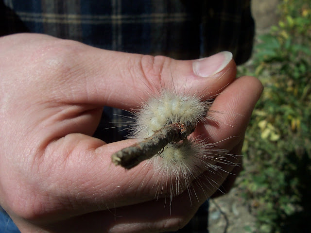
These are a couple alpine-style caterpillars we nearly stepped on. At this point they had about three weeks to turn into butterflies (or moths, probably) and get their business done before the snow flies.


The mottling of white feathers on this ptarmigan foreshadow Winter's approach. [edited 07.24.2019: according
to those who would know, this is a Dusky Grouse, not any kind of ptarmigan.] We spotted him/her on the road as we admired Bird Woman Falls.

Our Rising Sun Campground neighbor's dog went nuts as this deer passed through one morning.

We didn't spot any of the park's famous bears this time (we'd seen several at Many Glacier with my family), but our friend Esther, who came with us, saw one on the National Bison Range as we drove up.

Next: Going-to-the-Sun

September 4, 2007

VWs in GNP

We've been up to Glacier National Park again, and this is the start of a few posts' worth of pictures from that trip. First up are a few of the VWs we saw in and around the park. Less one 1970s Karmann Ghia (seen tooling down the Pacific side of Logan Pass while we were hiking), in fact, these are all the (air-cooled, anyway) VWs we saw in and around the park...

...plus a couple Wasser-pumpers of interest. At Rising Sun Campground we discovered that with Ludwig's arrival we'd completed a three-generation span of the VW bus/camper platform (the presence of a Splitty would've made the picture complete). This is a 2003 Eurovan Westy, the last year that they sent them to the US. A retro-new VW bus is allegedly in the works, but it's tough to get very excited about VW's apologist vehicles, e.g. the "New" "Beetle".

Next was this snappy 1989 Vanagon Westfalia, owned by a nice Manitoban couple on "permanent vacation". The moniker they've attached to their little apartment-on-wheels is indicative of the diverse ways owners think of their rides. Ludwig is named such partly because we think of him as a tough little guy ("Ludwig" means "famous warrior"). At the whole other end of the spectrum however, this Vanagon-who is certainly more powerful than Ludwig-is named "Tinkerbell".

For completeness' sake, here's Ludwig at Rising Sun with Red Eagle Mountain in the background. Twenty-nine years of Westfalias in one campground; I'll bet that doesn't happen often, at least not by accident.

At the Two Medicine entrance, the ranger gave us a "Nice bus". Then we noticed the blue camper (a Riviera, not a Westfalia; note the thicker poptop) across the way which, of course, turned out to be his. He told us he's spent whole Summers living in this 1978.

Last but not least was this late-70s bay in West Glacier who, if the sticker on his side is accurate, serves as a shuttle for a local hotel. There's that Carter-era candy bar paint scheme again.

Next time: less busses, more park.